Has been the focus recently for NOT building dams on the river or any others that flow into it
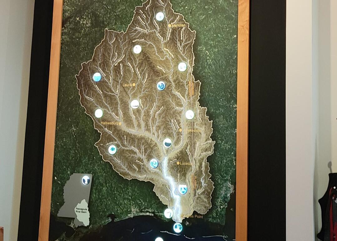
Formed in MW George County where the Leaf and Chickasawhay Rivers merge and flow south through swampy bottomlands through George and Jackson Counties.
Several channels and bayous in the lower course of the Pascagoula River
Main channel passes through Escatawpa and Moss Point and flows into the Sound at Pascagoula
Compass Rose – The Singing River Indians
Lower 8 miles of the Pascagoula River is known as the Singing River
Known for its mysterious music that sounds like a swarm of bees, it is best heard in late evenings during late summer and autumn. The old legend connects the sound with the mysterious extinction of the Pascagoula Tribe of Indians The Pascagoula were a gentle tribe of contented, innocent, and inoffensive people. The Biloxi Indians, on the other hand, considered themselves the ‘first people’ and were enemies of the Pascagoula. Anola, a Biloxi Indian princess, was in love with Altama, Chief of the Pascagoula tribe. She was to marry a chieftain of her own tribe, but she ran away with Altama to his people. The Biloxi Indians waged war against the Pascagoula Indians so they could “rescue” Anola. The Pascagoula warriors swore they would either save the Chief and his bride, Anola, or perish with them. The Pascagoula were outnumbered and faced becoming slaves of the Biloxi. With their women and children leading the way, the Pascagoula joined hands and began to chant a song of death as they walked into the river until the last voice was hushed by the dark, engulfing waters. Many believe the modern day sound is that of the death song of the Pascagoula tribe. Various hypothetical scientific explanations have been offered for this phenomenon, but so far none have been proven.
Biodiversity
Biodiversity is simply the variety of life forms on the earth. The term is often used to describe the different number of species found within a given habitat or ecosystem.
The Pascagoula River Basin is home to a vast amount of organisms because of its unique "untouched" state. It is the last unregulated and unimpeded major river system in the lower 48 states.
Because the river basin has experienced limited human disturbance, this has kept the Pascagoula basin’s natural flooding process. This natural flooding process carries nutrients, food, and other animals into the floodplain thus increasing the biodiversity of plants, animals, and resources available within its habitats.
This strong ecosystem with high biodiversity benefits humans because it provides us with ecosystem services including filtering our drinking water, soil regeneration, breaking down organic material, oxygen production, and crop pollination by insects.
The Pascagoula River Basin is highly diversified in its habitat types. The upper regions of the basin consist primarily of gently rolling hills and expansive flat floodplains, while the central portion lies within the Pine Belt. This area, sometimes called the “Piney Woods”, is scattered with Pine-dominated forests in moderately to poorly drained flat areas. Much of this habitat use to be a part of the longleaf pine belted forests which have declined over the centuries.
What remains of the longleaf pine forest is critical in supporting rare or endangered species such as the red-cockaded woodpecker, gopher tortoise, eastern indigo snake, and the black pine snake. These long leaf habitats are upland forests dominated by fire-resistant longleaf pine with an open grassland understory. It is fire-dependent with periodic fires (every three to five years) maintaining the dominance of longleaf pine and the open understory. In the absence of fire, this habitat transitions to southern mixed hardwood forests.
Southern mixed hardwood forests are upland forests with a variety of hardwood and coniferous trees with an understory of small trees and shrubs. These forests are the natural progression of longleaf pine forest in the absence of periodic fire. This habitat contains high biodiversity in plant species because it mirrors the classic forest structure described above. (canopy-understory-shrubs- herbaceous plants)
Closer to the Coast, drainage areas are low-lying flatlands which consist mainly of Bottomland hardwoods, and estuarine habitat. Bottomland hardwoods are wetland forests consisting of a variety of wet-tolerant hardwood trees, shrubs and herbaceous plants located within the floodplain of moderate to large rivers. These areas are inundated by seasonal flooding to varying extents depending on proximity to the river and elevation.
The Estuary is the near-shore ecosystems defined by a zone where freshwater mixes with salt water, particularly associated with large rivers such as the Pascagoula. These areas include tidal marshes and shallow open-water areas that are highly productive due to river-deposited nutrients and act as “nurseries” to a number of marine and estuarine aquatic organisms.
Flood regime in the Pascagoula River
The Flood Regime of a natural, unaltered river system like the Pascagoula is simply defined as the frequency and characteristics of flooding within the basin. Usually this frequency is based on rainfall, temperature, and the physical characteristics of the rivers drainage basin.
The Pascagoula River's flood regime is most often a annual event that occurs during the rainy winter/early spring months. High water levels overflow the river banks and are discharged into the surrounding habitats. These surrounding, low lying areas are called the flood plain. Most of the flood plain in the Pascagoula River consist of bottom land hardwood habitat and supports many different species of plants and animals. Because of this, the Pascagoula is similar to tropical low lying rivers that occur in Central and South America.
As flood water inundates the flood plain, it mixes with or "resupplies" water that is already present and pushes out stagnant water that may harbor high levels of algae and lead to hypoxia or the loss of oxygen. This water also carries vital nutrients, silt, sediments, seeds, and food to the flood plain as well as aquatic species that capitalize on the new resources available outside of the river channel. This is the main reason that the habitats within the flood plain of the Pascagoula river are extremely healthy and diverse with a vast array of plants, trees and animals. When the flood water recedes, it also carries large amounts of silt, sediments and nutrients downstream which helps support the aquatic food chain.
The Pascagoula River is an unaltered system. This simply means that there are no dams on the river, or the river channel as not been deepened. This maintains the connection of the river to the flood plain. Dams, channelization, and reservoirs stop the normal high and low water temporal patterns and the seasonal distribution of nutrients and sediments. This is extremely important for biodiversity and the productivity of a vast array of invertebrate species and the large number of higher order species that feed on them.
Forest – Habitat Profiles
Diverse types of trees throughout the Pascagoula River Basin support more habitats and biomes that we could possibly name
Plants and animals depend on these trees for life, food, shelter, and a means to exist.
Bayhead Swamp (Coastal Plain - Wetland)
General Description
Bayhead swamps are forested wetlands found at or near the heads of smaller tributaries of large drainage basins or as the main part of smaller or local drainage systems. These wetlands drain quickly following rain events. Commonly occurring trees include sweet bay magnolia (Magnolia virginiana), swamp black gum (Nyssa biflora), red bay (Persea palustris), red maple, (Acer rubrum), slash pine (Pinus elliotti), and sweetgum (Liquidambar styraciflua). Common shrubs include wax myrtle (Myrica cerifera), large gallberry (Ilex coriacea), and titi (Cyrilla racemiflora). The ground or herb layer commonly consist of cinnamon fern (Osmunda cinnamomea), royal fern (Osmunda regalis var spectabilis), netted chain fern (Woodwardia areolata), lizard’s tail (Saururus cernuus), sphagnum moss (Sphagnum spp), with occassional grasses and sedges. Laurel-leaf greenbriar (Smilax laurifolia) is also common.
Geographic Distribution
Bayhead swamps occur throughout the coastal plain region of the southeast, representing integral components of the drainage systems of any upland and many wetland habitat types.
Geomorphology/Hydrology/Soils
This habitat type occupies the upper portions of linear basins that help to drain surface water from the landscape. This habitat typically drains almost completely after rain events. Soils are hydric, composed of varying combinations of sand, silt and clay.
Major Plant Communities
The plant communities of this habitat types are basically as describe above. Additional plants species that may occur are listed below.
Common Plant Species
Canopy
Sweet Bay Magnolia (Magnolia virginiana)
Swamp Black Gum (Nyssa biflora)
Slash Pine (Pinus elliotti)
Loblolly Pine (Pinus taeda)
Spruce Pine (Pinus glabra)
Red Maple (Acer rubrum)
Yellow Poplar (Liriodendron tulipifera)
Red Bay (Persea palustris)
Sweetgum (Liquidambar styraciflua)
American Holly (Ilex opaca)
Shrubs
Titi (Cyrill racemiflora)
Large Gallberry (Ilex coriacea)
Wax Myrtle (Myrica cerifera)
Black Wax Myrtle (Myrica heterophylla)
Orderless Wax Myrtle (Myrica inodora)
Swamp Azalea (Rhododendron viscosum)
Wild Raisin (Viburnum nudum)
Fetterbush (Lyonia lucida)
Sweet Shrub (Calycanthus floridus)
Virginia Willow (Itea virginica)
Poison Sumac (Rhus vernix)
Poison Ivy (Toxicodendron radicans)
Ferns/Grasses/Forbs
Cinnamon Fern (Osmunda cinnamomea)
Royal Fern (Osmunda regalis var spectabilis)
Netted Chain Fern (Woodwardia areolata)
Lizard’s Tail (Saururus cernuus)
Sphagnum Moss (Sphagnum spp)
Sedges (Carex spp)
Spoon Flower (Peltandra sagittaefolia)
Blue-Flag Iris (Iris virginica)
Swamp Lily (Crinum americanum)
Wood Violet (Viola primulifolia)
Stokes Aster (Stokesia laevis)
Lianas
Laurel-Leaf Greenbriar (Smilax laurifolia
Gulf Connection
The Pascagoula River feeds into the Gulf of Mexico, discharging millions of gallons of fresh water a day into the Mississippi Sound. (the area of the gulf between the barrier islands and the southern shore of the Mississippi coast) The transition zone between the river environment and the marine environment is referred to as an Estuary. It is influenced by both tides and saltwater from the gulf, as well as fresh water from the river. This mixture of water is referred to as Brackish, and it contains high levels of nutrients which helps make estuaries one of the most productive and important habitats on the planet. The estuary ecosystem has mutual influences, and both the river and the gulf environments depend on similar processes and relationships.
The Pascagoula River basin plays an important role in maintaining the health of the estuary and the Mississippi sound because it replenishes nutrients and sediments via fresh water that supports wetlands and enters into the sea. Because the Pascagoula is a healthy, unaltered river system, the amount of naturally occurring nutrients produced from aquatic and terrestrial vegetation and phytoplankton flow to the sound and supply lower-level marine organisms with food. This increases and helps establishes a healthy marine food chain near the mouth of the river and the surrounding gulf. The Pascagoula River estuary zone also supports higher species diversity than non-riparian areas (river corridor) and makes the adjacent Gulf of Mexico a very healthy area for a greater variety of marine species.
Wetlands within the Pascagoula estuaries are highly productive ecosystems that provide precious spawning, foraging, and hiding places for many marine fish species. These habitats are often referred to as "nursery grounds" for commercial and recreational fish species during parts of their life stages. Because of the proximity of the gulf to the estuary, some scientists have suggested that fish prey production is heavier in the adjacent Mississippi sound.
Raptors of the Gulf (birds of prey)
Pascagoula River is known for its osprey nests on top of telephone poles, dead trees, electric towers, and anywhere else they can build a large flat nest.
Osprey rely on the river, its channels and bayous for their food, which is fish
Gulf Sturgeon
Sturgeons are an ancient group of fish dating back about 200 million years. The Gulf Sturgeon, also known as the Gulf of Mexico Sturgeon, is one of the world’s most endangered fish because they rely on healthy, unimpeded river systems to mate and spawn. Because the Pascagoula River has no impoundments or dams, this fish has used the river system for thousands of years to breed, and currently uses it to this day. They can live for about 60 years, but average 20 to 25 years. Gulf Sturgeon grow to 9 feet in length and weigh an excess of 300 pounds. They have a row of armored plates, called scutes, on their sides and back and range in color from a light neutral color to dark brown with a white underbelly. The Pascagoula Basin, particularly the Bouie River near Hattiesburg, is a critical nursery ground for these fish and only a few rivers have the characteristics to host the sturgeons life cycle.
Sturgeons Life Cycle:
Adult Gulf Sturgeon spawn in the freshwaters of the Bouie River ( a sub-basin of the Pascagoula) and migrate into marine waters in the fall to forage and overwinter. Riverine habitats where the healthiest populations of Gulf Sturgeon are found include long, spring-fed, free-flowing rivers, typically with steep banks, and a hard bottom. Gulf Sturgeon range from the Florida panhandle, to southeast Louisiana. These prehistoric fish initiate movement up the Pascagoula River between February and April and migrate back out to the Gulf of Mexico where they feed around the Mississippi barrier islands between September and November. They return to their natal stream to spawn. Spawning occurs in areas of clean substrate comprised of rock and rubble. Their eggs are sticky, sink to the bottom, and adhere in clumps to snags, outcroppings, or other clean surfaces. Juvenile Gulf Sturgeon stay in the river for about the first 2-3 years..
They spawn in up river reaches during the early spring and young-of-the-year (YOY) spend 6–10 months feeding in the river as they migrate down stream. They appear in the estuaries in December through February. Juveniles (< 6 years; except YOY) are believed to overwinter in the estuary. In Mississippi, large sub-adult and adult Gulf sturgeon have been shown to overwinter in the Mississippi Sound, congregating near the passes between barrier islands. The estuaries provide a essential link in the life history of Gulf sturgeon, ranging from a travel corridor connecting vital spawning and summer in-river holding areas, to nearshore and offshore marine feeding areas.
Gulf sturgeon are bottom feeders, and eat primarily macroinvertebrates, including brachiopods, mollusks, worms, and crustaceans. All foraging occurs in brackish or marine waters of the Gulf of Mexico and its estuaries; sturgeon do not forage in riverine habitat. Gulf Sturgeon have also been known to jump 6 feet out of the water.
Life Cycle & Reproduction
Gulf sturgeon are anadromous as adults (>1250 mm or four feet fork length), meaning that they spend time in both saltwater and freshwater, like salmon. Adults migrate upriver from the Gulf of Mexico in the springtime to spawn, returning to their natal streams to spawn, again similar to salmon.
Female Gulf sturgeon reach sexual maturity at 8-17 years of age. Males mature slightly earlier, at 7-12 years of age. Gulf sturgeon eggs are sticky and sink to the bottom, where they adhere in clumps to snags, or outcroppings.
They spawn in freshwater and migrate into marine waters in the fall to forage and overwinter. Juvenile Gulf sturgeon (304-890 mm FL) stay in the river for about the first two to three years and then move to the estuary where they forage until they reach sub-adult sized (891-1250 mm FL or three to four feet). Then they move to the barrier islands to forage, generally between December and March.
Tidal Marsh
A tidal marsh (also known as a type of "tidal wetland") is a marsh found along rivers, coasts and estuaries which floods and drains by the tidal movement of the adjacent estuary, sea or ocean. Tidal marshes experience many overlapping persistent cycles, including diurnal and semi-diurnal tides, day-night temperature fluctuations, spring-neap tides, seasonal vegetation growth and decay, upland runoff, decadal climate variations, and centennial to millennial trends in sea level and climate. Tidal marshes are formed in areas that are sheltered from waves (such as beside edges of bays), in upper slops of intertidal, and where water is fresh or saline. They are also impacted by transient disturbances such as hurricanes, floods, storms, and upland fires.
Oxbow Lake Formation
An oxbow lake forms when a large river naturally meanders or curves in “S” shaped patterns. The river eventually creates a shortcut by eroding the land at the neck, or the narrow end of the meander and completely removes the meander from the river’s current. Oxbow lakes are, in essence, the leftover curves of a river. They are so named because they resemble the bow pin of an oxbow, the collar placed around an ox’s neck to attach it to a plow.
The formation of the oxbow is described in this way: The flowing water moves faster around the outside bend of a river than on the inside bend of a river. Overtime, faster water on the outside bend erodes the river bank. Slow moving water, which is a key feature of the Pascagoula River, deposits sand and mud on the inside bend. The deposited sand and mud creates a river beach or slip-off slope. The channel continues to erode while depositing material on the inside which builds landmass. Eventually the curves of the river channel become very close as the process continues over time and the meander changes shape and grows in size. The river eventually breaks through this thin barrier of land mass. The water no longer flows round the meander, but straight along the new channel. The old course of the river channel becomes the oxbow lake.
Oxbows are generally shallow, stillwater lakes where water does not actively flow into or out of the lakes. Some oxbow lakes gain water via drainage canals or annual floods, but others do not. In these cases, sediment can gradually fill the lake and it can transition into a swamp or marsh before eventually drying up. When an oxbow lake is completely dry it leaves behind what is called a meander scar. Regardless of the oxbow-river connection, the abundance of invertebrates in oxbows is usually considerably higher than in the main river channel.
Oxbow lakes are important wildlife habitats capable of supporting a variety of species, and can be rich in biodiversity. These habitats have the potential to contribute to the fish community of the main river by providing spawning and nursery habitat for many freshwater species, and they are often important habitats for rare or endangered plants because of their unique wetland environment.
Migratory Interstate
The Pascagoula River basins healthy and un-fragmented forests support a wide range of species, but it plays a very critical role for migratory birds. Migrant birds travel from areas that have decreasing resources to locations that have higher or increasing resources. This equates primarily to food and available nesting locations. Birds that nest north of the equator migrate northward in the spring because of developing insect populations, new spring growth of plants, and available nesting locations. In the fall, as the number of insect species decline, the birds travel back southward.
The Pascagoula River basin is very important in this process because it acts as a migratory corridor or “highway” for these migrants and the basins healthy habitats supply resting areas and resources for the birds during their travel. MISSISSIPPI FLYWAY. Most importantly, these diverse habitats are key to their survival because the act of migration is a physically demanding process. Long distant migrants may fly 500 or more miles without stopping. When they do stop, they need food and resting areas to refuel for their continued journey. Because the habitat in North America has been dramatically fragmented, the intact Pascagoula River Basin is a migration refuge for hundreds of bird species. In the basin alone, we have documented 327 species out of the 400 bird species in Mississippi.
The riparian areas or lands that occur along rivers and water bodies are also important in the support of migrants that nest within the basin. These areas are distinctly different from surrounding lands because of the soil type and vegetation that are influenced by the presence of water. One example of a species that depends on these areas is the Prothonotary Warbler which migrates northward in the spring and nest within the bottomland hardwood habitat. Its numbers have dramatically decreased over the years because of habit loss. The availability and condition of riparian habitat can directly determine their health and survival.
From the headwaters of the Mississippi to the Gulf of Mexico (From Audubon website)
More than 325 bird species make the round-trip each year along the Mississippi Flyway, from their breeding grounds in Canada and the northern United States to their wintering grounds along the Gulf of Mexico and in Central and South America.
Many of those birds and their critical habitats were profoundly affected by the Deepwater Horizon oil spill—habitat that will be further eroded by sea-level rise. Audubon knows that only a comprehensive restoration program, and a long-term financial commitment to restoring the Gulf, will keep the flyway hospitable to birds.
We’ve established a Gulf-wide stewardship plan for the full range of coastal waterbirds, and this year Audubon received the first installment of funding from the National Fish and Wildlife Foundation to get those restoration projects started.
We protect Whooping Cranes, Least Terns, Prothonotary Warblers, and many other species at both the north and south ends of their migrations. From Minnesota, where we successfully lobbied the Environmental Protection Agency to stay the permit of a sulfide ore mine, to shorebird stewardship projects in Mississippi, we are there for the birds.
Mississippi Sandhill Crane
Mississippi Sandhill Cranes are one of six subspecies of the Sandhill Crane and one of three that are non-migratory. All Sandhill Cranes are gray overall with a red unfeathered crown and white cheek patch. These birds depend on the isolated wet-pine savanna habitat that is supported by the Pascagoula River Basin. The Mississippi Sandhill crane does not migrate and breeds and nest only on and near the Refuge and no other place on earth. These birds were added to the United States' List of Endangered Fish and Wildlife on June 4, 1973. Because of heavy habitat loss, today their numbers are only just over 100 individuals including 20-25 breeding pairs.
Mississippi Sandhill Cranes make their home on the fragmented sections of wet-pine savannah which are open, nearly treeless, fire-dependent plant communities dominated by well-developed ground cover and some low-growing shrubs with only scattered trees. Wet-pine savannahs have more moisture in the soil and also contain occasional ponds with cypress trees. This wetland habitat is extremely important for the nesting behavior of the Mississippi Sandhill Crane because they make mound-like nests in standing water with vegetation growing in it. Their nests consist of the dominant vegetation and both mates gather the nest material. The female lays 1to 3 eggs. Typically, one chick will survive and stay with its parents for 10 months.
Mississippi Sandhill Cranes are monogamous and choose life-long mates based on their elegant dancing displays. Displaying birds stretch their wings, pump their heads, bow, and leap into the air. Mississippi Sandhill Cranes may eat adult and larval insects, snails, reptiles, amphibians, nestling birds, small mammals, seeds, and berries.
Please consider visiting the Mississippi Sandhill Crane Wildlife Refuge to learn more about these fascinating and endangered birds.
Horn Island
The Pascagoula River's un-obstructive flow to the Gulf of Mexico has a profound impact on Horn Island, the southern most barrier island from the mouth of the river. Because there are no reservoirs or dams on the Pascagoula, nutrients and sediment are not trapped and flow freely to the Gulf. This influence extends to the maintenance and health of the island and the entire estuary.
Barrier Islands can form in multiple ways, but Horn Island is an example of Accretion of Offshore Shoals. Accretion is the process of growth or enlargement by gradual buildup. In the case of Horn Island, it is believed that an offshore shoal was built up higher and higher over time from vegetation washed onshore which grew and trapped sand. Over the years, it ‘accreted’ or grew to be the island that it is today.
The barrier islands serve as the southern border of the estuary essentially stabilizing the salinity levels of the Mississippi sound where saltwater from the gulf passes between islands and enters into the sound. Historically, the sound as been impacted by a reduction in the quantity and timing of freshwater entering the sound from the Mississippi River. Flood control mechanisms along the Mississippi River in New Orleans often release an "unbalanced" amount of fresh water into the Mississippi Sound disrupting the natural development of oyster reefs and tidal dependant fish embryos.
Sediment and nutrients flowing from the Pascagoula river play a key role in establishing the food chain along the northern shore of the island especially with sea grasses, blue crab, and other "feeder fish". Horn Island along with the other barrier islands are considered critical habitat for threatened and endangered species such as the Gulf sturgeon, sea turtles, and the piping plover. The islands beach and near shore habitats are used by terrestrial mammals, invertebrates, fish, wetland plants, submerged aquatic vegetation, marine mammals, and marine and coastal birds. Fish including the Redfish (Red Drum), Speckled Trout (Spotted Seatrout), Flounder, Triple Tail, Black Drum, White Trout (Sand Seatrout), Menhaden, Mullet and Cobia are all found in abundance around Horn Island. A safe environment and great feeding ground make it the perfect nursery for many species of sharks including Atlantic sharpnose, blacktip, spinner, bull, finetooth and bonnethead sharks.
Recording Buoy – Gulf Connection
Pascagoula River feeds fresh water into the MS Sound, which is the area between the barrier islands and southern shore of the MS coast.
This transition zone is known as an Estuary. It has both fresh water and salt water mixed together, known as Brackish water.
These Brackish waters are rich in nutrients and are the most productive and important habitats on earth.
The fresh water from the river replenishes the nutrients and sediments into the Sound that helps the “babies” grow and mature. The salinity of the water is very important measurement in order to ensure the estuaries remain productive for many species.